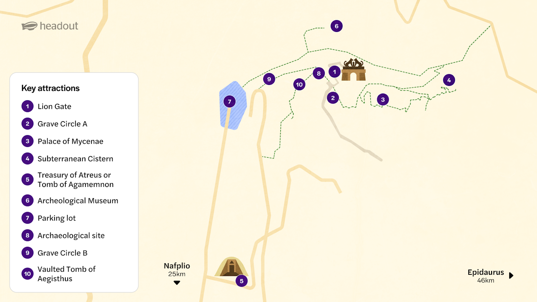
Mycenae map & site layout guide for visitors

The Archaeological site of Mycenae is a hilltop citadel packed with royal tombs, palace ruins, and giant stone walls. Most of the key attractions are either inside or just outside the fortified area. The terrain is uneven and often sloped, so having a site map helps you plan your route and timing efficiently.

Where is the Mycenae Archaeological Site located?

The Mycenae Archaeological Site is located in the northeastern Peloponnese region of Greece, in Argolis.

Address: Mykines 212 00, Argolis, Greece

Find on map

It’s about 120 kilometers (75 miles) southwest of Athens and roughly a 25-minute drive from the town of Nafplio. The site is well-signposted and easily reachable by car or guided tour.

Mycenae map

Map of Mycenae highlighting key attractions like Lion Gate and Palace of Mycenae.

Key zones of the Mycenae Site

Early mycenaean settlements around Acropolis

Lion Gate & Cyclopean Walls

This is the dramatic main entrance to ancient Mycenae, flanked by the famous lion relief. The surrounding Cyclopean Walls, built with massive limestone blocks, once protected the heart of the citadel.

Early mycenaean settlements around Acropolis

Tips for navigating the Mycenae Archaeological Site

  • Arrive early: Visit early in the morning or late afternoon to avoid crowds and harsh midday sun. Know that there’s minimal shade throughout the site.
  • Parking advice: Use the main lot near the entrance. If full, be cautious of ditches when parking along the road.
  • Be prepared for walking: Wear sturdy shoes and bring water, a hat, and sunscreen. Paths are sloped and uneven, especially around the cistern and palace.
  • Facilities available: Toilets, a café, and a gift shop are located near the museum at the main entrance.
  • Suggested route:

    1. Enter through the Lion Gate and see the Grave Circle A and Granary.
    2. Head uphill to the Palace Complex and religious areas.
    3. Visit the Underground Cistern near the North Gate.
    4. Explore lesser-known Beehive Tombs left of the main entrance.
    5. End with the Museum and then walk or drive to the Treasury of Atreus.
  • Time your visit to Treasury of Atreus: Visit the Treasury of Atreus at the beginning or end to avoid tour group crowds. It’s 400 meters from the main gate and has nearby parking.
  • Time needed: Set aside at least 2 hours to comfortably see the entire site, museum, and Treasury of Atreus.

Frequently asked question about Mycenae’s map

Yes, printed maps are usually available at the ticket counter in both English and Greek. They provide a clear layout of the citadel, museum, and surrounding tombs.